ISS tracker with the plug and make kit!
Ever wondered where the ISS is right now? Or how close it is to you? Then this project will solve that mystery!
Devices & Components
1
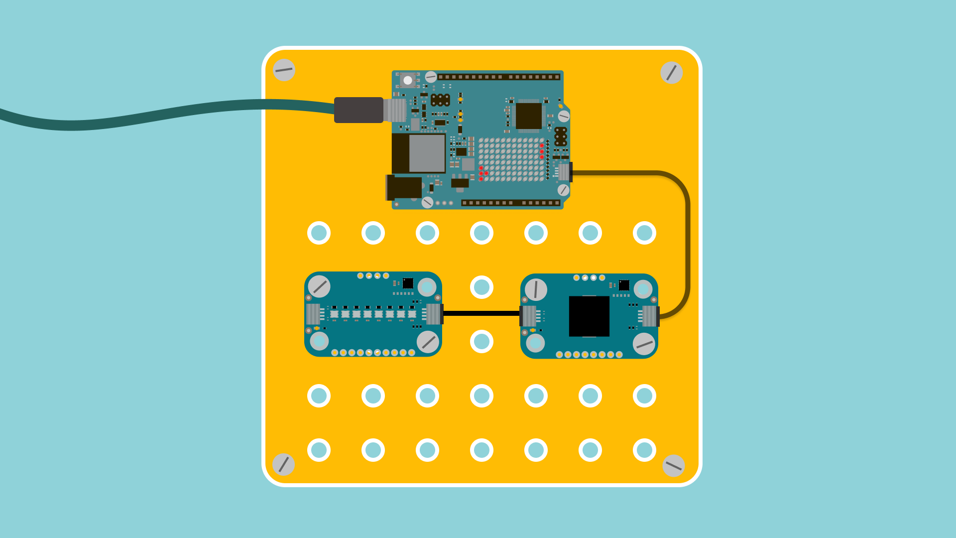
Arduino Plug and Make Kit
Software & Tools
Arduino IDE
1
Arduino Cloud
Project description
Code
drawings.h
csharp
LED Matrix drawings
1const uint32_t farAway[] = {
2	0xe00c0000,
3	0x600,
4	0x60ffffff
5};
6
7const uint32_t gettingCloser[] = {
8	0x3c018000,
9	0x600,
10	0x60ffffff
11};
12
13const uint32_t contact[] = {
14	0xf006000,
15	0x600,
16	0x60ffffff
17};
18
19const uint32_t leaving[] = {
20	0x3c01800,
21	0x600,
22	0x60ffffff
23};
24
25const uint32_t leavingFar[] = {
26	0x700300,
27	0x600,
28	0x60ffffff
29};
30
31const uint32_t animation[][4] = {
32	{
33		0x80000,
34		0xc8124212,
35		0x40180000,
36		1
37	},
38	{
39		0x20,
40		0xc8124212,
41		0x40180000,
42		2
43	},
44	{
45		0x0,
46		0xc9124212,
47		0x40180000,
48		3
49	},
50	{
51		0x0,
52		0xc8125212,
53		0x40180000,
54		4
55	},
56	{
57		0x0,
58		0xc8124a12,
59		0x40180000,
60		5
61	},
62	{
63		0x0,
64		0xc8124212,
65		0x401a0000,
66		6
67	},
68	{
69		0x0,
70		0xc8124212,
71		0x50180000,
72		7
73	},
74	{
75		0x0,
76		0xc8124292,
77		0x40180000,
78		8
79	},
80	{
81		0x0,
82		0xc8124252,
83		0x40180000,
84		9
85	},
86	{
87		0x0,
88		0xc8124212,
89		0x42180000,
90		10
91	},
92	{
93		0x0,
94		0xc8124212,
95		0x40181000,
96		11
97	}
98};
ISS Tracker
c
ISS tracker sketch for UNO R4 WiFi
1#include "arduino_secrets.h"
2#include "thingProperties.h"
3#include <math.h>
4#include "Arduino_LED_Matrix.h"
5#include "drawings.h"
6#include <ArduinoJson.h>
7#include <ArduinoHttpClient.h>
8#include <Modulino.h>
9
10ArduinoLEDMatrix matrix;
11
12// Define Modulino Pixels and Buzzer
13ModulinoPixels leds;
14ModulinoBuzzer buzzer;
15
16ModulinoColor DAYTIME_COLOR(100, 100, 0);  // Yellow
17ModulinoColor NIGHT_COLOR(0, 0, 100);      // Blue
18
19// Define melody for Buzzer
20int melody[] = { 262, 196, 196, 220, 196, 0, 247, 262 };
21
22int brightness = 25;
23
24// Keeps track of which direction the ISS should be going on the LED matrix
25bool dirSwitch = false;
26
27// Enter your coordinates:
28float myLatitude = 55.611826087732084; // Malmo, Sweden. You can edit this with your location
29float myLongitude = 12.97776190663195;
30
31// Variables for ISS location
32float spaceLong, spaceLat, distance;
33
34// Variable for time of day of ISS
35String timeOfDay;
36
37void setup() {
38  // Initialize serial and wait for port to open:
39  Serial.begin(9600);
40
41  // This delay gives the chance to wait for a Serial Monitor without blocking if none is found
42  delay(1500);
43
44  // Initialize matrix and Modulino
45  matrix.begin();
46  Modulino.begin();
47  leds.begin();
48  buzzer.begin();
49
50  // Give more time for WiFi connection to stabilize before NTP sync
51  delay(2000);
52
53  // Defined in thingProperties.h
54  initProperties();
55
56  // Connect to Arduino IoT Cloud
57  ArduinoCloud.begin(ArduinoIoTPreferredConnection);
58
59  // Allow time for NTP sync to complete
60  delay(1000);
61
62  setDebugMessageLevel(2);
63  ArduinoCloud.printDebugInfo();
64
65  // Print a message to confirm coordinates are set for Guatemala City
66  Serial.println("ISS Tracker initialized for Guatemala City");
67  Serial.print("Latitude: ");
68  Serial.print(myLatitude, 6);
69  Serial.print(", Longitude: ");
70  Serial.println(myLongitude, 6);
71}
72
73void loop() {
74  // Handle IoT Cloud updates
75  ArduinoCloud.update();
76
77  // Print a message showing we're attempting to get ISS position
78  Serial.println("Fetching ISS position...");
79
80  // Calls a function that will get the ISS position
81  getISSposition();
82
83  // If we successfully got ISS data
84  if (spaceLat != 0 && spaceLong != 0) {
85    Serial.print("ISS Position - Lat: ");
86    Serial.print(spaceLat, 6);
87    Serial.print(", Long: ");
88    Serial.println(spaceLong, 6);
89
90    // Calculate distance in km
91    calculateDistanceInKm();
92
93    // Update cloud variable with ISS location
94    isslocation = Location(spaceLat, spaceLong);
95    displayDistance = distance;
96
97    // Update visibility and message based on distance
98    if (distance < 400) {
99      visibility = 100;
100      message = "Eyes to the sky ISS is here!";
101    } else if (distance < 600) {
102      visibility = 90;
103      message = "Get ready ISS almost in-view!";
104    } else if (distance < 1000) {
105      visibility = 70;
106      message = "ISS approaching - prepare for sighting";
107    } else if (distance < 1500) {
108      visibility = 50;
109      message = "ISS detected in your region";
110    } else if (distance < 2000) {
111      visibility = 30;
112      message = "ISS approaching your area";
113    } else if (distance < 2500) {
114      visibility = 10;
115      message = "ISS in tracking range";
116    } else {
117      visibility = 0;
118      message = "ISS too far for viewing";
119    }
120
121    Serial.print("ISS Distance: ");
122    Serial.print(distance);
123    Serial.print(" km, Visibility: ");
124    Serial.println(timeOfDay);
125
126    // Display time of day with the Modulino pixels
127    displayLEDs();
128  } else {
129    Serial.println("Failed to get ISS position data");
130  }
131
132  // Checking the distance and drawing on the LED Matrix according to how close the ISS is
133  if (distance > 3500) {
134    matrix.loadSequence(animation);
135    for(int x = 0; x < 11; x++){
136      uint32_t nr = x;
137      matrix.renderFrame(nr);
138      delay(3000);
139      matrix.next();}
140    dirSwitch = false;
141    Serial.println("ISS is very far away");
142  } else if (distance < 1000) {
143      for (int i = 0; i < 8; i++) {
144        int note = melody[i];
145        buzzer.tone(note, 250);
146        delay(250);}
147      matrix.loadFrame(contact);
148      dirSwitch = true;
149      Serial.println("ISS is extremely close!");
150      delay(5000);
151  } else if (distance < 2500) {
152      if (dirSwitch) {
153        matrix.loadFrame(leaving);
154        Serial.println("ISS is leaving");
155    } else {
156        matrix.loadFrame(gettingCloser);
157        Serial.println("ISS is getting closer");
158    }
159    delay(5000);
160  } else { // This covers 2500-3500 km
161      if (dirSwitch) {
162        matrix.loadFrame(leavingFar);
163        Serial.println("ISS is moving farther away");
164      } else {
165        for (int i = 0; i < 8; i++) {
166          int note = melody[i];
167          buzzer.tone(note, 250);
168          delay(250);}
169        matrix.loadFrame(farAway);
170        Serial.println("ISS is far away");
171      }
172      delay(10000);
173    }
174}
175
176void getISSposition() {
177  int httpPort = 443;
178  char serverAddress[] = "api.wheretheiss.at"; // server address
179  WiFiSSLClient wifi;
180  HttpClient client = HttpClient(wifi, serverAddress, httpPort);
181
182  // Add more helpful debug information
183  Serial.print("Connecting to ");
184  Serial.println(serverAddress);
185
186  // Set timeout for HTTP client to prevent hanging
187  client.setTimeout(10000);
188
189  // Make the API request
190  client.get("/v1/satellites/25544");
191
192  // Get the status code
193  int statusCode = client.responseStatusCode();
194  Serial.print("HTTP Status code: ");
195  Serial.println(statusCode);
196
197  if (statusCode != 200) {
198    Serial.println("Failed to get ISS data");
199    return;
200  }
201
202  String result = client.responseBody(); // Collects the API response
203
204  if (result.length() > 0) {
205    Serial.print("Response length: ");
206    Serial.println(result.length());
207
208    DynamicJsonDocument doc(32000);
209    DeserializationError error = deserializeJson(doc, result);
210
211    if (error) {
212      Serial.print("JSON parsing failed: ");
213      Serial.println(error.c_str());
214      return;
215    }
216
217    // Extracts the information from the API call
218    spaceLong = doc["longitude"];
219    spaceLat = doc["latitude"];
220    timeOfDay = String(doc["visibility"]);
221    velocity = doc["velocity"];
222
223  } else {
224    Serial.println("Empty response received");
225  }
226}
227
228void calculateDistanceInKm() {
229  int R = 6371; // Radius of the earth in km
230  float converter = M_PI / 180;
231  float calculateLat = (spaceLat - myLatitude) * converter;
232  float calculateLon = (spaceLong - myLongitude) * converter;
233
234  float a = sin(calculateLat / 2) * sin(calculateLat / 2) +
235            cos(myLatitude * converter) * cos(spaceLat * converter) *
236            sin(calculateLon / 2) * sin(calculateLon / 2);
237  float c = 2 * atan2(sqrt(a), sqrt(1 - a));
238  distance = R * c; // Distance in km
239}
240
241// Helper function to set a pixel with a color
242void setPixel(int pixel, ModulinoColor color) {
243  leds.set(pixel, color, brightness);
244  leds.show();
245}
246
247void displayLEDs() {
248  // Set the LEDs to yellow for daylight
249  if (timeOfDay == "daylight") {
250    for (int i = 0; i < 8; i++) {
251      setPixel(i, DAYTIME_COLOR);
252      delay(25);  // Small delay between LEDs for effect
253    }
254  }
255  // Set the LEDs to blue for eclipsed
256  else if (timeOfDay == "eclipsed") {
257    for (int i = 0; i < 8; i++) {
258      setPixel(i, NIGHT_COLOR);
259      delay(25);  // Small delay between LEDs for effect
260    }
261  }
262}
263
264void onDisplayDistanceChange()  {
265}
266
267void onVisibilityChange()  {
268}
269
270void onMessageChange()  {
271}
Downloadable files
Connection Guide
overview-001.png
Comments
Only logged in users can leave comments